Tenbury
Situated on the southern bank of the River Teme, Tenbury is a small town nestled in the heart of the Teme Valley, whose undulating landscape is a mosaic of rich red cultivated soils, hilly pasture flocked by cattle and sheep, and stretches of ancient woodland interspersed with scattered farmsteads and small villages. This setting was one familiar to early modern visitors. Gibson’s (1695, 527) edition of William Camden’s Britannia notes that the region possessed ‘rich meadows, and the soil on both sides [of the Teme] produceth excellent Syder, and Hops in great abundance’, while at the end of the eighteenth century the topographer James Baker (1795, 242) described its ‘rich and spacious’ countryside, noting how ‘in summer…none exhibits on its bounds larger or more varied successions of productive plantations of grain, cyder-fruit and hops’.
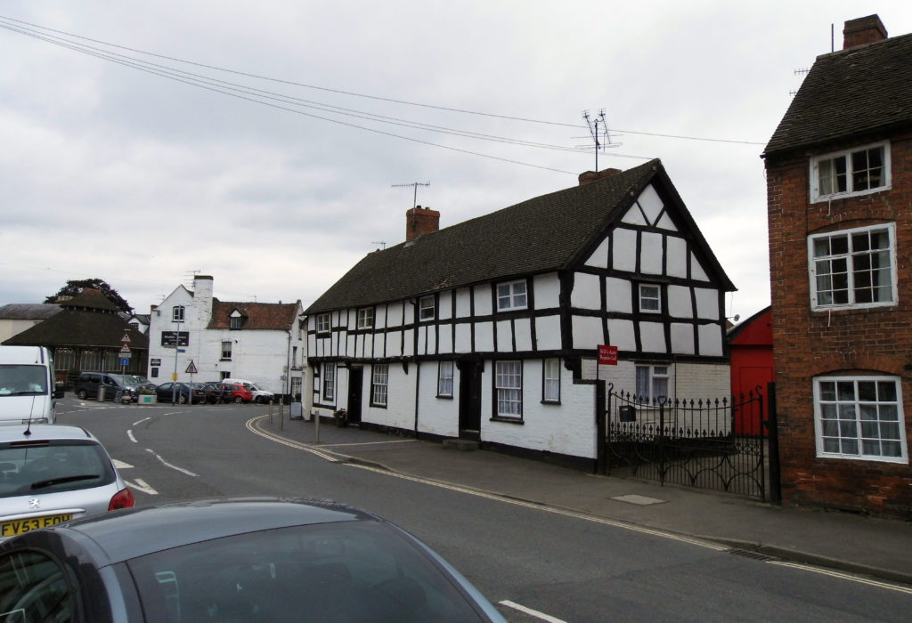
Grade II listed houses at 1 and 3 Cross Street, Tenbury, built c.1600
The town’s origins are somewhat enigmatic. Archaeological finds from the hinterland of Tenbury attest to settlement in the area from at least the Romano-British period, but no textual affirmation of Tenbury’s status as a town occurs until the provision of a borough charter in 1455. There are some hints, however, that the town may have had at least a quasi-urban character during the early and high medieval periods. In the early eleventh century Tenbury was held as an estate of the monks of Worcester, and it may have possessed one of several poorly-documented minster churches believed to have existed in the West Midlands during the early middle ages (Bond 1988, 134); similar evidence for a focal character is suggested by the earliest recorded form of its place name, Temedebyrig (‘the burh by the Teme’), which may hint at a function as a stronghold or similar fortified estate at an early date (Dalwood 2005, 2-3). Eleventh century charters referring to a ‘Port Street’ suggest an early market site, a role confirmed by the provision of a royal charter in the 1220s granting Tenbury a weekly Thursday market. By the 1240s a new charter shifted market day to Tuesday, and provided for an annual two-day fair around the feast of the Translation of Thomas the Martyr on the 7th of July (Letters 2013).

Grade II listed late sixteenth century inn, The Old Royal Oak, on the north side of Market Street, Tenbury
Unlike some other small towns in the region, Tenbury weathered the worst of the storms of late medieval urban decline, and by the early seventeenth century it had become an entrenched player in the market hierarchy of West Midlands towns. Its resilience was tied in no small part to its location, which lay close to the termini of two major roads – one from London, the other from Montgomery – meeting at Ludlow, a major livestock market and the seat of the Council of the Marches. Unsurprisingly, therefore, Tenbury repeatedly appears in seventeenth century pocket books and traveller’s guides as a stopping point for traders heading along these routes (Hopton 1612, 207). Its annual fairs in April, July, and September seem also to have had an independent commercial interest, and would have been important dates in the agrarian calendar for those living in and around the Welsh border (Jones 1690, 43).

Grade II listed late sixteenth century inn, The King’s Head, on the west side of Cross Street, Tenbury
The occupational structure of the seventeenth century town very much reflected its dual role as a centre of local trade and the early modern version of the motorway service station. Indentures, wills, and quarter sessions rolls relating to the town record tanners, butchers, blacksmiths, dyers and glovers, who would have depended on the local cattle farming and iron industries for their activities; other professions attested include mercers, pedlar, apothecary, victuallers, and innkeepers, who derived their incomes from the purses of locals and visiting traders alike. Yet, for all the traffic it carried, the town was only ‘a small, but well-frequented market-town’ (Gibson 1695, 527). The hearth tax returns of 1664/5 record 124 households in the parish of Tenbury, 71 of which were located in the town and the remainder in the scattered hamlets surrounding it, and factoring in exclusions and making allowances for household populations produces a population estimate of c.790 people; this is not magnitudes below the guesstimate of c.930 people recorded in the Bishop of London’s 1676 ecclesiastical census.
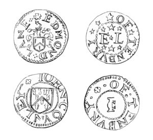
Farthing tokens of Edmond Lane and John Counley of Tenbury (after Cotton 1885, pl. IV nos. 27-28).
Three people from Tenbury are known to have issued tokens during the seventeenth century:
John Counley
Edmond Lane
Anthony Search
The tokens issued include both halfpence and farthings.
References
Baker, J. 1795. A picturesque guide through Wales and the Marches. Vol. III. Worcester: J. Tymbs.
Bond, C.J. 1988. Church and parish in Norman Worcestershire. In J. Blair, ed. Minsters and parish churches: the local church in transition, 950-1200. Oxford: Oxford University Committee for Archaeology. pp. 119-158.
Cotton, W.A. 1885. The coins, tokens, and medals of Worcestershire. Bromsgrove: The Messenger.
Dalwood, H. 2005. Archaeological assessment of Tenbury Wells, Hereford and Worcester (including part of Burford, Shropshire). Worcester: Central Marches Historic Towns Survey,
Gibson, E. 1695. Camden’s Britannia, newly translated into English: with large additions and improvements. London: F. Collins.
Hopton, A. 1612. A concordancy of yeares. Containing a new, easie, and most exact computation of time, according to the English account. London: Company of Stationers.
Jones, T. 1690. Newyddion mawr oddiwrth y sêr. London: T. Jones.
Letters, S. 2013. Gazetteer of markets and fairs in England and Wales to 1516. London: Centre for Metropolitan History.